19 June, 2011

19 June, 1944

V-MAIL

438th AAA AW BN
APO 403 % Postmaster, N.Y.
France
19 June, 1944         0915

Wilma darling –

Still on V-mail ration, dear, but soon I may be able to find a spot to write an Air-mail. A wonderful thing happened yesterday when I got two letters from you – one written May 31st and the other June 5th – with a cute postcard enclosed. It sure was good to get – and the Army is doing a swell job in keeping the mail going. I’m sure you must be hearing fairly regularly by now, sweetheart.

CLICK ON PICTURES TO ENLARGE

Mobile Post Office near Cherbourg

News from here is scant. The radio must be keeping you up to date with what’s going on. We’re a part of the picture, all right, but it has not been bad. I’m getting toughened up in the hands and shoulders from digging in – wherever we go. That is absolutely the first thing we do.


Foxholes by a Stream in Normandy

The food situation hasn’t been too bad. Haven’t been able to spend any money. All our English money was turned into francs before we left. Each franc is worth two cents – so that we all have francs in the thousands. They come in paper notes, 5 francs, 50, 100, 500 1000 – etc. and all in different sizes – so you can’t get them into you wallet right. All for now, darling. Remember I love you terribly and miss you and think of you constantly. My love to the folks and remember – don’t worry!!

All my love, dear
Greg

* TIDBIT *

about The Mulberry Harbors and the Storm

CLICK ON PICTURE TO ENLARGE

Mulberry Harbor B at Arromanches

To enable the forces already on the Normandy coast on D-Day to be reinforced and kept supplied with utmost speed it was necessary that two invasion ports be constructed in England, then be transported across 100 miles of sea and placed in position off the enemy occupied coast. It was estimated that about 12,000 tons, plus 2,500 vehicles of all kinds, would have to be unloaded each day for 90 days at least. The only possible plan was to have prefabricated sections which could be assembled at the spot where two vast invasion ports would be most useful - Mulberry A for the USA beaches of Omaha and Utah and Mulberry B for the British and Canadian beaches of Gold, Juno and Sword. Each harbor would have a capacity of 7000 tons of vehicles and supplies per day. Caissons would be towed across the Channel, each by a tug of about 1,500 hp. On arrival they were to be maneuvred into position with the help of small tugs, then special valves would be opened in each, allowing water to fill it and sink it where it was to remain. The designs would allow for the floating caissons to be secured in place in four days.

On D-Day blockships sailed to where this work was to be completed, to provide breakwaters for the immediate shelter of hosts of small craft. Sixty ships of various types and sizes were earmarked for this purpose, including old warships. These made the crossing close behind the assault forces and all arrived safely. They were sunk by explosive charges, and their crews were then brought back to England. To complete each port, internal equipment such as piers was essential. It was no easy matter to construct a pier hundreds of feet long on a flat beach, with a rise and fall of tide of over 20 feet, and which sometimes may be floating and at other times be resting on sand or, worse still, rock.

After severe sea tests the equipment went into production amounting to 7 miles of pier and all necessary appurtenances. Pier heads were built, as ships, in various ports on the coast of the UK, from Leith round to Glasgow. Most of the remaining equipment was prefabricated all over the country, and then assembled at the Army depots at Southampton and Richborough. About 240 contractors were employed on this particular task, and 50,000 tons of steel were used. The work of assembly-on-the-spot went on whilst the sinking of caissons was being completed. By D-Day plus 12 more than half of these were in position, and the harbors were already an impressive sight. Floating breakwaters, consisting of steel floats, had previously been moored end-to-end in a long line, to provide a damping effect on the sea in strong winds; 15,000 tons of steel were used in their construction. The Army Fire Service helped in sinking the pier heads to the correct level.

CLICK ON PICTURES TO ENLARGE

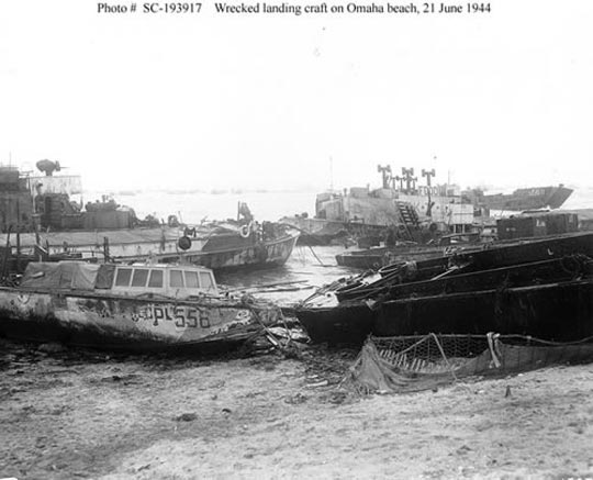
And then, on 19 June, the biggest June gale for 40 years began. It blew for three days from the worst possible direction. The harbors, only half-way built, were exposed to its full force. The American harbor, Mulberry A suffered very severely and the breakwaters were largely broken up. The destruction was so great that the work on this harbor was discontinued. Mulberry A was in use for less than 10 days. Out of 31 caissons laid in position, 21 were damaged beyond repair by the storm, with broken backs and sides. Mulberry A was never used again and parts of it were scavenged to repair damage to Mulberry B. The Americans quickly reverted to the traditional methods of unloading from landing craft and DUKWs ("Ducks") directly onto the beaches, often coming in on one tide and leaving on the next. Such was their success that on occasions they exceeded the impressive performance achieved at Mulberry B.

The six photos below show the damage done
to landing craft and pontoons.

CLICK ON PICTURES TO ENLARGE


All the pier equipment which was on the voyage across when the gale started was sunk, but only one caisson failed to weather the journey. After the gale subsided, the work of construction continued on Mulberry B, the British harbor at Arromanches, though a long spell of rough weather prevented pier equipment from being towed over, so that the remaining harbour was not unloading to maximum capacity until well into July. But even on the worst day 800 tons of petrol and ammunition, as well as many troops, were landed over the piers. Eventually it was completed, and a port bigger than many with famous names had been built in a few weeks against a lonely French beach.

Day after day, in all weathers, scores of ships of all sizes had moored within its shelter or berthed in unbroken lines along its quays. Never, even at the height of a peacetime trade boom, had so much shipping used such limited accommodation at one time. Each day around 9000 tons were landed via Mulberry B until the end of August by which time Cherbourg port became available for use, at least in part. Towards the end of the year, after the capture of Walcheren, the port of Antwerp also was made available. In all, Mulberry B was in use for 5 months during which time over two million men, half a million vehicles and 4 million tons of supplies passed through the harbor. During this period several additional caissons where used to reinforce weak points in the breakwater.

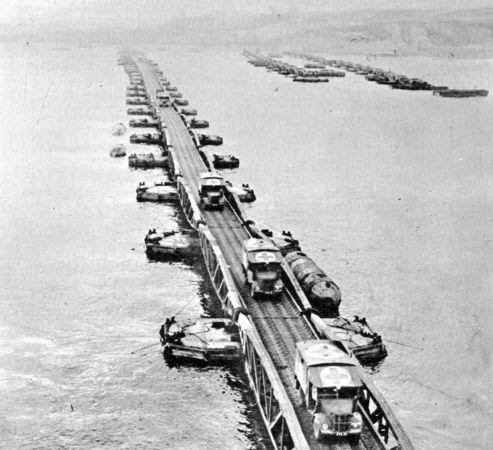
The following photos show vehicles and half-tracks
coming and going at Mulberry B.

CLICK ON PICTURES TO ENLARGE

18 June, 2011

18 June, 1944

V-MAIL

438th AAA AW BN
APO 403 % Postmaster, N.Y.
France
18 June, 1944

Dearest sweetheart -

It doesn’t seem like Sunday today although someone just reminded me that it was in fact. One day runs into the other in an amazing manner. I can’t write you much, darling, exasperating as it must be for you – but that is the way it has to be for now. I can give you some impressions though. The country here – Normandy – is very pretty and has an air or age about it that makes even parts of England seem modern. I’ve had occasion to go to some native farm houses and have got quite a kick out of making myself understood. Quite a bit of my French is coming back and the people seem to understand it – anyway. I wouldn’t say the people are unduly friendly, although not hostile of course. As for myself, sweetheart, I can only say that I now love you from two foreign countries – England and France – and that’s something. I can’t believe I’m actually in France – but I’ll get used to it soon. Believe me, dear, that regardless of distance and excitement – you are never out of my mind and your picture which is always with me in my shirt pocket – has been great comfort. Love to the folks and explain to everyone – Mother, Granny, Mary etc. that I haven’t written because there’s been no time.

All for now dear.
My deepest love –
Greg

* TIDBIT *

about The VII Corps and the Cherbourg Campaign - Part 2

CLICK ON MAP TO ENLARGE

With the seizure of the bridges at St. Sauveur-le-Vicomte and Ste. Colombe, the 82d Airborne Division and the 9th Division had completed the mission of clearing the east bank of the Douve River as far north as Ste. Colombe. By the evening of 16 June, the 82d Airborne Division securely held St. Sauveur, west of the Douve. About the same time, leading elements of the 9th Division also established a bridgehead across the Douve, at Ste. Colombe. These gains broke the main enemy resistance; and while the 82d pivoted to the south to protect the corps' left flank, the 9th continued its attack to the west, fanning out into open ground through both the Douve bridgeheads. Early on 18 June, the 9th Division occupied Barneville, and by evening, the VII Corps had driven a corridor five miles wide across the peninsula. The enemy north of the corridor counterattacked in a vain effort to reestablish contact with the Germans to the south and then fell back in some disorder toward Cherbourg.

CLICK ON PICTURE TO ENLARGE

Aerial view of Barneville-Carteret looking south.
Barneville and the Channel are on the right, Cateret at the bottom.
On 18 June 1944 the U.S. 9th Infantry entered Barneville
4 years to the day after the Germans had entered the town.

The prime objective of the VII Corps was achieved: the Cotentin Peninsula was cut in two according to a line which connecting Utah Beach and Barneville. The German forces defending the surroundings of Cherbourg, the new objective of VII Corps, could not join their lines in the South any longer and were condemned to receive no more supplies. There were nearly 40,000 men in this critical situation. The Americans, on their side, maintained the pressure and kept bombarding the German lines of defense which moved back hour per hour. The engagements were violent, although the defenders' morale was low.

The cutting of the peninsula by the 9th Division marked the end of a phase in the VII Corps' operations in the Cotentin Peninsula. With the southern flank of the Corps secured, and the remaining German units bottled up in the peninsula, the Corps could now make a coordinated attack northward to its final objective, the port of Cherbourg. Generals Bradley and Collins decided to use three divisions for the attack to the north. The 4th Division launched a surprise night attack near Montebourg, and the 79th and 9th Divisions began their northward advances early the next morning. That evening, as the 4th and 79th closed in on Valognes, the Germans decided to withdraw to the strong defensive perimeter they had established in the hills around Cherbourg.

Later on 18 June, General Manton Sprague Eddy, commander of the 9th Infantry Division, commended his troops for their accomplishment, and General Montgomery, commander of 21st Army Group, sent personal congratulations to the VII Corps commander, General J. Lawton Collins, on the "roping off" of the peninsula.

17 June, 2011

17 June, 1944

V-MAIL

438th AAA AW BN
APO 403 % Postmaster, N.Y.
Somewhere in France
17 June, 1944

Hello darling!

I know you don’t like V-mail letters – but I’ll switch to Air-mail at the first opportunity. From the heading – you can see we are now allowed to state our general location. I understand that we now have an APO here for outgoing mail so I hope this gets to you soon.

No doubt you’re anxious, dear, to know about all that has happened – but really, darling, nothing much here. I’m well and safe and not the least bit worried. Naturally, it has been thrilling, but hell – to have been in the Army for 2 years and have missed this – would have been disappointing. Anyway, dearest, all is under control and I’m taking good care of myself for you – so don’t worry too much! Remember, dear, I love you and miss you. Will write more when I can. Love to the folks

All my love
Greg

Route of the Question Mark


Part of Page 11 of The Route of the Question Mark gives this time frame:
June 17: Headquarters Battery arrives in Normandy, D plus 11, and we participate in the Invasion as part of the 109th AA Group, VII Corps, First Army, taking part in the Normandy Campaign, the Race to Paris, the drive across Northern France, the Battle of the Bulge, and the Battle of Germany.

Pages 21-22 include this portion:
The Greek ship Hellas, which certainly lived up to the first syllable of its name... The confusion of the marshalling area... The congestion on the docks at Southampton, and the misery experienced by all... Headquarters Battery doggedly carrying its baseball equipment right into the face of the enemy... The thrill of seeing the coast of France, Hitler's Fortress of Europe, the real thing, not a news-reel, for the first time... Utah Beach, where all the ships in the world appeared to be waiting to unload... The antiaircraft barrage... The false gas alarm... The interminable delays... The de-water-proofing area, and the first fox-holes...


Troop Ship Nea Hellas

Normandy... The famous hedge-rows... The dead cattle... The stunned civilians... Ste. Mere Eglise... Valognes and Montebourg... Our first glimpse of what War can do to a town... Mines cleared to hedges... The unbelievable concentration of traffic and equipment on the roads of the beach-head... The summer weather... The heat... The apple orchards... The Ten-in-one rations... The first free rations of cigarettes... The crashed gliders... Parachute silk for 'kerchiefs... The start of our long itinerary........


CLICK ON PICTURES TO ENLARGE

U.S soldiers take cover behind dead cattle in Normandy.


Beach-head Traffic


Crashed Gliders
in Normandy.


*TIDBIT*
about Ten-in-One Rations


Ten-in-One Rations

Ten-in-one rations were designed for troops in all areas to be used in advance of arrival of field kitchens. Each case provided food for ten men for one day. Items were non-perishable and could be eaten either hot or cold. Five menus were offered, with each ration providing 4,100 calories. Each case included cigarettes, water purification tablets, matches, salt, can openers (The famous P-38), toilet paper, toilet soap and paper towels.

16 June, 2011

16 June 1944

No letter today. Just this:

* TIDBIT *

about The VII Corps and the Cherbourg Campaign

CLICK ON MAP TO ENLARGE


On the 16th of June, the 438th AAA AW Bn (M) was assigned the task of defending two vital bridges on the main supply line which had just been established at St. Sauveur-le-Vicomte. They were also assigned to defend VII Corps Artillery for the cutting of German forces on the Cherbourg Peninsula and the attack on Cherbourg. Greg's unit was certainly in the thick of it...

On the afternoon of 15 June General Collins announced: "The major effort of the Corps is now to cut the peninsula." By this time the advance westward had progressed sufficiently so that the entire effort could be focused toward that end. For 16 June General Collins ordered an attack all along the line from the Douve River to Gourbesville. The 82d Airborne Division was to continue toward St. Sauveur-le-Vicomte. Developments in the vicinity of St. Sauveur-le-Vicomte suddenly changed the whole tempo of the battle. The 82d Airborne and 9th Division units jumped off at various times between 0500 and 0800 on the morning of 16 June, but it was the attack of the 325th Glider Infantry, Regiment (GIR) assisted by tanks of Company A, 746th Tank Battalion, which touched off the complete rout of the remaining enemy units east of the Douve and paced the 2-division drive to the Douve line.

At noon three regiments -- the 325th GIR, the 505th Parachute Infantry Regiment(PIR), and the 508th PIR which had joined the other two -- were poised on the east bank of the river overlooking the town of St. Sauveur-le-Vicomte. From this position the enemy could be observed withdrawing from the town. General Ridgway, realizing the possibilities of the situation, asked Corps'permission to cross the river into town and establish a bridgehead. Meanwhile he had the artillery deliver harrassing fire on the roads leading north, west, and south from the town. The 1st Battalion, 325th GIR, was alerted to cross the river and cut the road to the southwest. An hour after the Corps commander had approved General Ridgway's request, elements of the division were crossing the river, meeting little resistance. By dark a firm bridgehead was established and secured with a perimeter defense 2,000 to 2,500 yards out from the town. Engineers bridged the Douve and tanks entered the town that evening.

The events at St. Sauveur-le Vicomte were a turning point in the whole drive westward. The success of the 82d Airborne Division gave such impetus to the 9th Division's attack that it gathered a momentum which carried it swiftly across the peninsula.


Most of the pictures below come from:
PhotosNormandie's Flickr Photostream.

CLICK ON PICTURES TO ENLARGE

Aerial view of Saint Sauveur-le-Vicomte looking west.
In the foreground can be seen bomb craters, the Douve River and
its bridges. At the bottom right 2 trucks head toward Valogne.
The top center road leads to Portbail and across the picture
is the train line between Cherbourg and La Haye du Puits.


Pontoon bridge constructed by American military
engineers near Saint Sauveur-Le-Vicomte
Robert Capa © International Center of Photography/Magnum Photos


Ruins in Saint-Sauveur-le-Vicomte.
In this devastated neighborhood, one house was somehow left intact.


American soldiers shovel up the debris on
today's Rue du Vieux Château in
 Saint Sauveur-le-Vicomte.


These GIs shovel the wreckage of a collapsed house
on Rue Bottin-Desylles, next to a Renault garage
in Saint Souveur-le-Vicomte.


The Hôtel de la Victoire is destroyed. An American soldier
walks down what is now Rue du Vieux Château
after it was dug out in Saint Sauveur le Vicomte.


Soldiers of the U.S. 82nd Airborne, accompanied
by a jeep, walk down what is now Rue du Vieux Château.
Saint Sauveur-le-Vicomte is in ruins, 16 June 1944.

15 June, 2011

15 June, 1944

No letter today. Just this:

* TIDBIT *
about Hedgerows and the French Countryside

CLICK ON DIAGRAM TO ENLARGE

Diagram of a hedgerow

The terrain features of the French countryside had a particularly strong influence on the conduct of operations. The terrain on the Allied left, held by the British Second Army, was an expanse of gently rolling pastures and cultivated fields. The relatively dry and firm ground in the British sector facilitated armor operations and the construction of forward airfields. The boundary line between the British Second Army and the U.S. First Army began on the coast near Port-en-Bessin and extended inland for approximately twenty miles, ending a few miles east of the village of Caumont. The U.S. First Army was responsible for operations along a wide arc that stretched westward from Caumont to the port of Cherbourg, a frontage of more than fifty miles.

Within a few days after the Allied invasion of Normandy, the U.S. Army found itself facing a stubborn opponent on terrain that favored the defender. Units fought desperately for hills, towns, and bridges that had become of strategic importance. At every turn, the Americans faced the seasoned veterans of the German Army. The effects of weather and especially terrain had a direct influence on the conduct of operations, while the dispositions and defensive capabilities of the German Army crucially dictated American actions.

Unlike the terrain in the British sector, the ground held by the U.S. First Army did not favor mobile operations. The American sector on the left, the ground between the boundary line with the British and the Vire River, was broken and uneven.The countryside in this sector was a patchwork of small hills, low ridges, narrow rivers, and steep valleys that hampered long-range observation and impeded cross-country movement. The center of the American sector was low ground that contained extensive marshlands. The whole area was drained by the Taute and Vire Rivers, which empty into the English Channel near Carentan and Isigny, respectively. The marshlands were flat, and the ground was soft and moist making travel by foot difficult, with vehicle traffic being almost impossible. Heavy rains made the marshlands even less passable, restricting movement to the few asphalt roads that traverse the bogs. On the American right, the terrain was more favorable. Between the marshes in the center of the sector and the coastline on the extreme right flank, a group of hills rose up to dominate the northern end of the Cotentin Peninsula. The most important terrain feature on the American right was the city of Cherbourg with its extensive port facilities.

Despite these natural obstacles, the most pervasive and formidable barrier in the American sector was man-made. For centuries, Norman farmers had enclosed the plots of their arable land, pastures as well as orchards, with thick hedgerows. The hedgerows were sturdy embankments, half earth, half hedge. At their base, they varied in thickness from one to four feet, with heights from three to fifteen feet. Growing out of this earthen wall was a hedge that consisted of small trees and tangles of vines and brush. This vegetation had a thickness of one to three feet and varied in height from three to fifteen feet. The hedgerows surrounded each field, breaking the terrain into numerous walled enclosures. Because the fields were small, about 200 by 400 yards in size, and usually irregular in shape, the hedgerows were numerous and set in no logical pattern. Each field had an opening in the hedgerow that permitted access for humans, livestock, and farm equipment. For passage to fields that are not adjacent to regular highways, numerous wagon trails ran through the hedgerows.

CLICK ON IMAGES TO ENLARGE

Soldiers in trench between hedgerows, 10 June 1944


A breach in a hedgerow


A machine gun is set up in a hedgerow

The military features of the hedgerows are obvious. They divided the country into tiny compartments, providing excellent concealment to the defender a formidable obstacle to the attacker. The thick vegetation limited the deployment of units and restrict observation, making the effective use of heavy-caliber direct-fire weapons almost impossible and hampering the adjustment of artillery fire. Anyone occupying a high place that afforded good fields of observation and a clear view of the surrounding countryside had a distinct advantage.

The uneven and compartmentalized nature of this area meant paved roads were important. The main highways either paralleled the coast or stretched inland to the interior of Normandy. Carentan, in the center of the First Army's sector, was a vital road junction. From there, good highways ran eastward to Périers and La Haye-du-Puits. East of Carentan, two parallel roads ran south to Saint-Lo, which was perhaps the most vital road junction in the First Army sector. Like spokes on a wheel, roads ran from Saint-Lo in almost every direction. The force that could hold Saint-Lo would retain control over much of the road network in the wooded countryside.

Like the terrain, the weather also influenced operations in Normandy. More than anything else, persistent rains during June and July hampered the efforts of the U.S. Army. The early summer of 1944 was the wettest since 1900. Extended periods of rainy weather turned the marshlands west of Carentan into a bottomless morass, making cross-country movement impossible. Rains also added immeasurably to the daily miseries endured by the foot soldier. Low visibility and cloud ceilings often grounded all aircraft, denying the ground forces the support of fighter-bombers and aerial observers that was so desperately needed. The extent of daylight was also important. Extremely long days put a premium on the hours of darkness. Nighttime was used to rearm, resupply, rest, and plan for the next day's operations. Short nights limited the amount of time for these activities, and early dawns often found exhausted American units unprepared to conduct an attack or to defend against counterattacks.

14 June, 2011

14 June, 1944

V-MAIL

438th AAA AW BN
APO 403 % Postmaster, N.Y.
14 June, 1944

Dearest sweetheart –

Again I can write you just a few lines with not much in the line of news, I know, but just to let you now that everything is well with me. I hope you are not worrying too much, darling, although I know a certain amount would be natural these days. But honestly, dear, I’m comfortable, relaxed, eating and sleeping regularly and taking things in stride.

That’s all for now, sweetheart. I think of you constantly and find great solace in the thought of our love for each other – for which I am ever thankful. Give my love to the folks, dear.

All my love to you
Greg

* TIDBIT *

about D-Day plus 8

CLICK ON MAP TO ENLARGE


On 14 June, VII Corps launched an offensive to seize the badly needed portfacilities at Cherbourg. There was much to do to get there.

In the West, the American forces moved towards the north of Utah Beach. The 9th Infantry Division, near the 4th Infantry Division, was ordered to liberate the town of Quinéville, home of Germany's Regional Headquarter. With the capture of Quinéville on 14 June, the enemy's main line in the North was broken, depriving him of his best natural defense against the advancing northern flank. The capture of Quinéville and the clearing of the coast to the south also helped to speed the landing of supplies and personnel for VII Corps. In the early days of the landings German artillery had prevented the use of the Navy pontoon causeway built on D plus 1, and difficulties in beaching landing craft and in the functioning of the ferry control organization had resulted in a lag in unloading of about thirty-six hours.

Cherbourg, which was to be under the Ally control on June 14th according to the May 1944 plans, was still far away. But the 9th American Infantry Division progressed all the same towards Valognes, despite heavy losses while the men of the 82nd Airborne Division attacked in direction of the village of Saint-Sauveur-le-Vicomte. This description of the action of the 505th Parachute Infantry Regiment (PIR) of the 82nd Airborne Division to take Saint-Sauveur-le-Vicomte, beginning on 14 June, was written by Pat Curran for a former page on DdayHistorian.com:

On Wednesday, 14th June the attack to take St.-Sauveur-le-Vicomte began from a jump off west of Etienville. This phase of the 505th Normandy campaign lasted for four days. The attack commenced at 9:30am on Wednesday 14th June with the 507 PIR in the lead and the 505th in Division reserve following behind. The two paratroop regiments advanced westward on the north of Etienville to St.-Sauveur-le-Vicomte Road.

To the 507th's right was the U.S. 9th Infantry, which overall was an experienced Division, having seen action in North Africa. However, some of its regiments had no battle experience at all. On the left flank and south of the road was the 2nd Battalion 401st Glider Infantry Regiment (GIR), attached to the 325th GIR. The 507th had suffered huge losses prior to this attack. It's 1st Battalion numbered just over 100 men, and fewer still by the time it reached the eastern outskirts of La Bonneville that night. The day had seen ferocious fighting on both sides of the road with the 2nd Battalion 401st GIR eventually pulling up in line with the 507th PIR as dusk fell on Wednesday night.

During the final leg of Company E, 401st's advance, the night became dark from overcast sky. Unbelievably, a German squad, by-passed during the day by the Americans, heard Company E troopers talking indistinctly through a hedgerow and thinking they were German troops, fell in behind the marching column. They only realized their mistake when the column halted and began to dig in. The German squad wisely surrendered without a fight!

From the World War Photos site comes this picture of the 82nd in Saint-Sauveur-le-Vicomte:
CLICK ON IMAGES TO ENLARGE

Meanwhile, northeast of the city of Bayeux, on the beach of Courseulles, General Charles de Gaulle, chief of the Free French Army, landed after crossing the English Channel aboard the destroyer "La Combattante", a ship of the Free French Navy.


DeGaulle walking in Couseulles, 14 June 1944

He met General Montgomery at his Headquarters at the castle of Creuilly. He then went to Bayeux, liberated on June 7, where an immense crowd applauded him and sang the "Marseillaise". He moved on to the towns of Isigny-sur-Mer and Grandcamp at the end of the afternoon, pressed by the Allies to come back as quickly as possible.


Creully Castle, Montgomery's Headquarters, France

13 June, 2011

13 June, 1944

No letter today. Just this:

Greg arrived on Utah Beach on 12 June, 1944 to join the VII Corps under Collins. The progress of VII Corps can be seen on the map below, where Allied forces are shown in blue and German forces in red.

CLICK ON MAP TO ENLARGE

Map of the movement of Allied and German Forces
from D-day to D-Day plus 6 (12 June, 1944).

The small town of Carentan occupied a pivotal position between Omaha and Utah Beaches, and its capture was one of the most important American priorities in the days immediately after D-Day. Carentan was naturally protected by the swamps of the lower Taute and Vire rivers, and artificially by inundations created by German flooding. The only good road across this area ran through Carentan and on to Périers, but this single road was very easily defended.

The 101st Airborne was given the task of taking Carentan. The only available approach to the town ran along another causeway that entered the town from the north. The attack had begun on 8 June, but progress was very slow. It took two days to reach Carentan, but on 10 June the 101st had begun to surround the town. On 11 June the paratroops had finally fought their way past the outer defenses of the town. The beleagured defenders of the town called for supplies to be dropped from the air, but no supplies appeared. On the night of 11-12 June, under heavy American fire, the Germans had abandoned Carentan. The gap between the beaches had seemed to be closed.

However, this battle wasn't over. Germany's Field Marshall Erwin Rommel saw the recapture of Carentan as essential to successfully defeat the Allied invasion. On 12 June he informed Keitel that he intended to move the focus of his operations west to Carentan and Montebourg, in an effort to destroy the American beachhead on the Cotentin Peninsula. On the same day he ordered the 17th SS Panzer Grenadier Regiment to retake the town. Fortunately for the Allies, Rommel's promised reinforcements were severely delayed by a combination of air attacks and sabotage by the Resistance.

The counterattack took place on the morning of 13 June. The SS troops reached to within 500 yards of the town before they were defeated by the 101st Airborne with help from the U.S. 2nd Armoured Division. The coordinated efforts of the tanks, infantry, and artillery threw the enemy back several thousand yards, inflicting an estimated loss of 500 men. Worse was to follow for the Germans, for the movement of the 17th SS had left a gap in their lines, which the U.S. 1st Division would exploit.

The capture of Carentan again closed the gap between the Utah and Omaha beachheads, the last gap between the D-Day landing zones. This was one of the most important moments in the battle of Normandy, for it removed any danger that the Germans might have been able to destroy the isolated Utah beach head. However, although the Allies were safely ashore, and their bridgehead, unless they made a major error, unlikely to be threatened, a grim battle of attrition lay ahead. The first major task was to complete the capture of Cherbourg, for nature was about to demonstrate the frightening vulnerability of the Allied forces until they held a major port.

CLICK ON PICTURES TO ENLARGE

The entrance in Carentan by Rue Holgate,
coming from Periers road.


Medical Jeep rides down Rue Holgate, Carentan


M-7 Tank rolls by Aid Station, Rue Holgate, Carentan


101st Airborne patrolling Carentan street


American howitzers shell German forces near Carentan